Lowell School Committee Districts are set
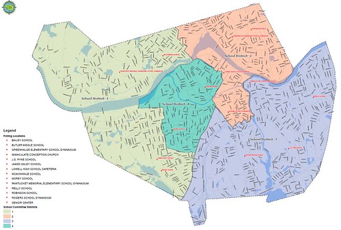
Map of Lowell School Committee election districts
The city of Lowell recently announced that the School Committee districts for the 2021 Lowell City Election have been set. Under the settlement of the Voting Rights Lawsuit brought against the city, the method of electing councilors and school committee members would change from the all members elected at large method used since 1959 to a hybrid model of some at-large, some district councilors and committee members.
Under the new system, there will be three councilors elected citywide (at large) and eight elected from eight districts. In two of the eight districts, a majority of the residents will be members of minority groups. In December, I wrote a blog post describing the geographic boundaries of the eight council districts and how they compared to our current ward and precincts.
Unlike the council which will increase from the current nine members to eleven, the school committee will remain the same size with six members elected by the public and the seventh member being the mayor who will be chosen the same way as before: on inauguration day, a majority of city councilors will select a fellow councilor to serve as mayor.
However, just two of the six school committee members will be elected citywide. The other four will be elected from individual districts. Because there are eight city council districts and only half as many school committee districts, council districts will be joined in pairs of two to create the school committee districts.
The following describes the make up of the school committee districts:
School Committee District 1
Consists of Council Districts 1 and 8
Council District 1 – Pawtucketville. Bounded to the north by the Tyngsborough and Dracut town lines; to the easy by University Ave; to the south by the Merrimack River; and to the west by the Tyngsborough town line. Demographics of District: 67.4% white, 15.0% Asian, 10.6% Hispanic, 5.1% Black. Includes current Wards/Precincts: 6-1, 6-2, 6-3, 5-1.
Council District 8 – Upper Highlands and Middlesex Village. Bounded to the north by the Merrimack River and then Middlesex Street from the Lowell Humane Society to Stevens Street. The eastern boundary is Stevens Street to Parker then Parker to Chelmsford (with Callery Park outside the district and Lowell Catholic inside the district). The eastern boundary continues along Chelmsford Street to the Chelmsford town line. The southern and western boundary is the Chelmsford town line back to the starting point at the river. Demographics of District: 53.5% white, 27.8% Asian, 9.5% Hispanic, 6.6% Black. Includes current Wards/Precincts: 8-1, 8-3, and parts of 8-2 and 3-3.
School Committee District 2
Consists of Council Districts 4 and 2
Council District 4 – East Pawtucketville, Downtown, and Chapel Hill. Starting in Pawtucketville at Sparks Street and the Dracut line, bounded to the north by the Dracut town line to Burnaby Street; to the east by Burnaby, Dalton, and Aiken Streets, with the northern bound continuing along the Merrimack River to the Concord River; bounded to the east by the Concord River to Rogers Street; then bounded to the south by a zig zag course of Rogers, Merrill, Lawrence, Swift, Chase, Mead, and Floyd Streets to Central Street. Then the southern bound continues along Central Street to Thorndike; then the western boundary continues along Thorndike to Dutton; then along Dutton to Arcand, along Arcand to Father Morissette Blvd, and then along Father Morissette Boulevard to the Merrimack River (at the Howe Bridge); then out University Ave, to Fourth Ave, to Sparks Street and the point of beginning. Demographics of District: 60.1% white, 9.4% Asian, 19.4% Hispanic, 7.1% Black. Includes current Wards/Precincts: 2-3, 10-3, and parts of 5-2, 5-3, 2-1, 2-2, 4-3, and 10-2.
Council District 2 – Centralville. Beginning at Burnaby Street and the Dracut line, bounded to the north and east by the Dracut town line; to the south by the Merrimack River; and to the west by Aiken Street to Dalton Street to Burnaby. Demographics of District: 55.0% white, 10.0% Asian, 23.6% Hispanic, 8.6% Black. Includes current Wards/Precincts: 9-1, 9-2, 9-3, and parts of 5-2 and 5-3.
School Committee District 3
Consists of Council Districts 3 and 5
Council District 3 – Belvidere. Beginning at the confluence of the Concord and Merrimack Rivers, bounded to the north by the Merrimack River; the east by the Tewksbury town line; the south by Boylston and Lawrence Streets; and the east by the Concord River. Demographics of District: 21.7% minority (6.9% Asian, 14.8% Hispanic, 4.0% Black. Includes current Wards/Precincts: 1-1, 1-2, 1-3, 11-3.
Council District 5 – South Lowell. Beginning at Thorndike and Chelmsford Streets, bounded to the east by Thorndike St to Central; bounded to the north by Central, Floyd, and the other streets listed as the southern boundary of District 5, to Rogers Street and the Concord River; then south along the Concord River to the intersection of Billerica and Lawrence Streets; then along Epping, Burton and Roper Streets to Rockingham Street; south along Rockingham Street to Lawrence Street; east on Lawrence Street to Boylston; south on Boylston to the Tewksbury line; then running to the west (forming the southern boundary) along the Tewksbury, Billerica, and Chelmsford town lines to Cross Point; then a western boundary along Chelmsford Street back to Thorndike. Demographics of District: 52.0% white, 21/5% Asian, 16.1% Hispanic, 6.4% Black. Includes current Wards/Precincts: 10-1, 11-1, 11-2, and parts of 4-3 and 8-2.
School Committee District 4
Consists of Council Districts 6 and 7
Council District 6 – Lower Highlands. Beginning at Stevens and Middlesex with a northern boundary along Middlesex, Branch, and Middlesex Streets to Chelmsford Street; then an eastern boundary along Chelmsford Street to Parker Street; southern boundary runs along Parker Street from Chelmsford to Stevens; western boundary runs along Stevens to Middlesex and the point of beginning. Demographics of District: 28.9% white, 50.0% Asian, 14.3% Hispanic, 4.6% Black. Includes current Wards/Precincts: 4-1, 4-2, and parts of 4-3, 3-2, 3-3, and 7-3.
Council District 7 – The Acre. Begins at Pawtucket Street at Lowell Humane Society; northern boundary runs along Pawtucket Street (and Merrimack River) and then along Father Morissette Bvld; boundary to east is Arcand Drive and Dutton Street to Middlesex Street; southern boundary is Middlesex-Branch-Middlesex to point of beginning at Middlesex and Pawtucket. Demographics of District: 33.3% white, 28.8% Asian, 29.6% Hispanic, 5.2% Black. Includes current Wards/Precincts: 7-1, 7-2, and parts of 7-3, 2-1 and 2-2.
NOTE: The lawsuit settlement required at least one of the school committee districts to have a majority of its residents be members of minority groups. That is School Committee District 4 (the Acre and Lower Highlands).
Below is the map showing the eight City Council Districts
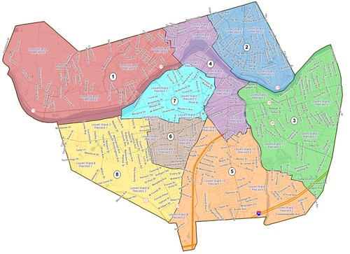
Lowell City Council election district map