The Middlesex Canal

The following is the second in my series of posts about the canals of Lowell. The first described the Pawtucket Canal.
The Proprietors of Middlesex Canal received its charter as a Massachusetts corporation on June 22, 1793, just a year after the incorporation of the group that would build the Pawtucket Canal. Unlike the Pawtucket Canal, which would allow waterborne transport to bypass the Pawtucket Falls and continue down the Merrimack River to Newburyport and the Merrimack River, the Middlesex Canal would take the same transports from the eastward turn of the Merrimack River at Chelmsford all the way to the Charles River and eventually Boston.
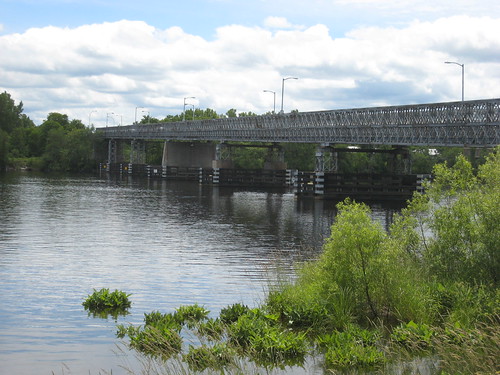
The Middlesex Canal came off the Merrimack in Middlesex Village, about one quarter mile east of today’s Rourke Bridge (shown below) right about where the Family Dollar Store (once Alexander’s Supermarket) is located today on Middlesex Street. The canal then ran southerly, parallel to Baldwin Street through what is now Hadley Field and on through today’s Mt Pleasant Golf Course. None of the canal remains visible in Lowell today (which is why I have no pictures to offer) but its history is maintained by the Middlesex Canal Association which has an extremely informative website.
The Middlesex Canal stretched 27 miles, had 20 locks and 8 aqueducts. It took 9 years to construct and ran through the towns of Chelmsford, Billerica, Wilmington, Woburn, Winchester, Medford and Charlestown. According to The Old Middlesex Canal by Mary Stetson Clarke, the canal provided “fifty years of safe, economical water transportation between Charlestown and Middlesex Village.” Winter proved a problem for the canal since it froze over during cold weather and the railroad proved to be its undoing. Consequently, the Middlesex Canal ceased operations in 1850.
Besides providing a much needed transportation link from the Merrimack River to Boston, the Middlesex Canal also contributed to the rapid financial demise of the nearby Pawtucket Canal. Why pay to ship your goods to Newburyport via the Pawtucket Canal when you could get them to Boston (and the higher prices buyers were willing to pay there) via the Middlesex Canal for the same price? But the failure of the Pawtucket Canal was not altogether a bad thing: had it been a vibrant transportation canal in 1822, the task of the industrialists who built Lowell would have been much more difficult.

This is a great idea for a series of posts.
It looks like a very small segment of the canal remains visible in the woods off of Route 3, right before it merges with Black Brook to run through the golf course. I’ve never been over there to know if it’s anything other than a ditch in a swamp (my guess is that that’s precisely all that’s there):
https://www.bing.com/maps/?v=2&cp=r33hpm91nbd9&lvl=17&dir=0&sty=b&where1=Olde%20Canal%20Dr%2C%20Lowell%2C%20MA%2001851&form=LMLTCC
Speaking of obliterated infrastructure, did you ever do a post on the Lowell Airport? I swear I saw one, but I can’t find it anymore.
https://www.airfields-freeman.com/MA/Airfields_MA_NE.htm
We have been on our snowshoes back there from Mount Pleasant and its pretty swampy. The Wang tower really looms over you.
General Butler Ames started the Lowell Airport Corporation. It’s over off Woburn Street, south of 495 on the Concord River side. You can see the remains of it on google maps.
Many years ago I read Thoreau’s “A Week on the Concord and Merrimack Rivers”, where he took a side trip up the Middlesex Canal. One phrase stuck with me, something to the effect that – time will wear away the vestiges of this canal, but it will still be visible through the overgrowth. At the time I checked the passageway near the golf club, and could discern the solid berms on either side of the old canal in some spots, the places where the horses pulling the barges trampled. I suspect they are still there, although even more growth and swamp may be making that more difficult to observe.
When I was a kid, my backyard abutted the former Middlesex Canal in Billerica. We lived on Canal St (Now Harvard Rd.) just off Gray Street near the MBTA railroad tracks. I was always fascinated by stories of the canal and my backyard sloped down to where you could imagine the horses puling the barges on the berms. Our neighbors had some of the berm still at the back of their property. The aqueduct on the Billerica, Wilmington line was a short distance Southeast. There was also a significant portion of the canal that was still largely intact running through the wooded area behind the high tension wires on Gray Street and behind the Billerica Landfill, (now closed). Some of that wooded area now has housing on it but I bet a good portion is still there abutting the back of the landfill. It was a great place to walk as a kid. We used to do our own digs back there and found quite a bit of old glass bottles and fragments.
Jason,
Check out http://www.middlesexcanal.org/photos/graypond
The Middlesex Canal Association leads bike rides along
the canal. http://Www.middlesexcanal.org
Fifty years of back issues of Towpath Topics, the newsletter of the M’sex Canal Ass’n, (in which research results are often published) can be found at . They contain a wealth of information about the canal and how it evolved. There is an index of content.
The canal lasted slightly longer than indicated. The last toll was collected in November, 1851; and the last known boat to pass through was in April of the following year. The canal was legally abandon in 1860.
The Pawtucket Canal may have suffered a reduction in traffic and revenue once the M’sex Canal began operation, but it is less clear that it suffered a ‘financial demise’. In 1818, 1819 and 1820, the Pawtucket Canal, which cost about $60K to build, paid $4, $3, and $3 to its investors. At the same time, the M’sex Canal, which cost $600K to build, paid $15, $10 and $10 to its investors.While more information is needed to compare the financial states of the two, the figures suggest that Pawtucket Canal continued to do an acceptable business.
You left the URL out of my reply. Please add back in.
Thanks
Sorry, but I can’t find any URL in your initial comment. If you want to put the URL in a new comment, I’ll watch for it and be sure it makes it onto the site.
Initially, the first paragraph read –
Fifty years of back issues of Towpath Topics, the newsletter of the M’sex Canal Ass’n, (in which research results are often published) can be found at https://middlesexcanal.org/towpath/. They contain a wealth of information about the canal and how it evolved. There is an index of content.
The URL is repeated in the web site field, above. –– You might also add:
From the green side of the Mt. Pleasant Golf Club House, if one walks west along the north perimeter of the green, before you reach Black Brook there will be a well preserved section of canal prism on your right. At this point, and all the way from Nichol’s Lock (about 11 miles to the east), the towpath was on the west/south side of the channel.
http://www.middlesexcanal.org/photos/lowest gate.jpg
The approximate location of the lowest gate of the
three Merrimack locks is north of the ne corner of
the former Sterling Transportation, based on an
1840 survey of the nearby Cyrus Baldwin property,
now Hadley Field. Good picture of Hadley the
locktender in Jan 2012? /Towpath Topics/.
https://www.masspaths.net/photos/middlesex20120401/
Two or three photos of the canal at Mount Pleasant.
The photos at 2012 April 01 are part of the April 1st Middlesex Canal tour.
Im obliged for the blog post.Thanks Again. Fantastic.