Amazing Vision for a New Lord Overpass

The city’s planning department hit a home run—make that a grand slam—with a radical new concept for the Lord Overpass, unveiled tonight at a public meeting at the Lowell Senior Center. City Manager Kevin Murphy opened the program by saying he felt a little like William Shatner because we were about to “boldly go where no planning department has gone before.” He wasn’t kidding.
City planners and consultants from VHB Engineering then walked the audience through the process that included an earlier public meeting in November, detailed analysis of traffic accidents, an extensive site visit that helped visualize the problems inherent in the current design, and much debate in the drawing room.
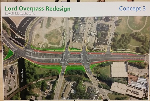
Their conclusion: the Lord Overpass should be filled in, with Thorndike Street in both directions rising at the same elevation as the existing up and down ramps to form twin intersections with Middlesex Street and with Chelmsford/Appleton Streets. Coming from downtown, you will be able to turn left or right onto Middlesex Street or go straight ahead. Coming from the Lowell Connector, you will be able to turn right onto Appleton, left onto Chelmsford, or go straight ahead. Most importantly, the safety and convenience of bikers and walkers will be greatly enhanced.
At several points during tonight’s presentation, the 70+ people in attendance broke into spontaneous applause. That’s not the usual response to the rollout of a new traffic pattern. There was applause because those in attendance recognize that this proposal undoes 50 years of failed traffic planning that centered on highways and fast-moving cars at the expense of people and neighborhoods.
I’ve compared the Dutton/Thorndike Street corridor to Lowell’s version of the Berlin Wall. It separates the western half of the city from the eastern half, and attempting to cross it puts your life at risk. This asphalt gash has been a major impediment to economic development for decades.
But with the forthcoming construction in the Hamilton Canal District, the proposal for the Thorndike Factory Outlet, and the tremendous potential for tying that all in to the Gallagher Terminal, the South Common, the lower Highlands, the Acre, and the rest of downtown, an innovative plan for the Lord Overpass that broke from the highway planning mold was desperately needed. Fortunately, the city has leadership courageous enough to take that step. There will be pushback—some people just can’t handle change—but if Lowell follows through on this project, the city’s already superb reputation as a forward-looking leader in post-Industrial urban planning will be considerably enhanced, and we, the residents of the city, will have a strengthened and more livable community to enjoy.

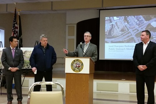
from left: Rep Rady Mom, Councilor Jim Leary, Manager Kevin Murphy, Manager Corey Belanger
I never thought the city would go for this. At the first public meeting, a man at our table suggested the “fill-in” idea. He explained and said that it had been successfully done in Portland, ME. Once I understood, I was all for it. So when CIty Manager Murphy said that they were proposing “The Big Fill” I cheered. Out loud. Kudos to the planners and I look forward to Public Meeting 3 on the subject.
Above comment is not from “Anonymous”. It’s Judith Durant.
Terrific writeup and an amazing plan for a totally new entrance for our city. Really ties it all together.
At first blush this radical change may be thought to break the bank, but without the need to replace two bridges, nor maintain them in the future, the life cost could well be less than the simpler approach. But a lot of thought will have to go into the planning, in order to keep things reasonable once construction begins.
They should’ve never done the old project, getting rid of the old railroad depot, what a shame. So was urban renewal loss lots of Canadian (immigrant history) they where the catalyst along with the Irish in making Lowell.
I will be glad to see changes that make it safer for walkers who are now walking on Thorndike street, so unsafe and scary for both walkers and drivers alike.
This is very encouraging. Kudos to City Manager Murphy, the City Council, and our City planners for innovative and forward thinking. This road design will reconnect parts of Lowell the way the Rose Kennedy Greenway now connects parts of Boston that for decades were divided by the elevated expressway.
If they cascade (“link”) the traffic lights all along Thorndike this likely will be a great success for everyone (walkers, bikers, drivers). Anyone who has ever driven in Manhattan knows how well cascaded traffic lights can work.
If they don’t, it adds more places for traffic to get jammed up. If it makes navigation worse in that way I could unfortunately see a revolt in future years against such changes.
Darn it. Been fighting that stupid rotary as long as I’ve been driving. Now that I move away, the city fixes it. The right way.
As always thank you for keeping us up-to-date. This plans sounds really exciting. It also sounds as if the process worked, that the city listened to what the people who showed up at earlier sessions had to say!
Do we know when the work might start and/or be finished?
Encouraging on two fronts. A major step in terms of better design. Also very encouraging to see the public hearing have such an impact.
This is great! One question, any chance of a green swath down the center? Thank you city of Lowell folks involved. Thank you VHB.
I wish I had known these meetings were happening. Thought I signed up to receive notices, but never received any.
I was shocked when I read the overpass would be filled in. It’s great that the city and engineering firm took public input and reworked the project. That said I’m glad there’s a 3rd public input session planned. I wanted to wait till more info came out before commenting but the Sun hasn’t covered this at all as far as I know.
From the pic above I see an abundance of dedicated turn lanes that will make crossing the street on foot no less arduous than its current state. It looks to be double the width of asphalt compared to where someone would cross at the train station. It reminds me of Daniel Webster highway in Nashua. Not somewhere I want to be outside of a car.
Eliminating the turn lanes would allow the city to sell the surplus land for development and generate tax revenue. Land use and how buildings meet the street are key factors in walkability. The current configuration of buildings in the vicinity don’t frame a good walking environment. Let’s make sure non-transportation land use considerations are built into the plan.
More questions:
Are there protected bike lanes linking DTL to the train station?
Where is the metered parking near the train station and Sal’s?
How wide are the lanes? Not more than 10 feet is the standard for safe speeds.
Could we use stop signs instead traffic lights to save money and keep pedestrian and traffic flow moving?
The current redesign is pretty good but I know we can do better.