Lowell Week in Review: April 30, 2017
Parking in Lowell
My Week in Review post last Sunday took up the issue of parking. It received some thoughtful comments. One disputed my assertion that from a traffic and parking perspective, Lowell was too big to operate like a small town and too small to operate like a big city. To the contrary, our in-between size is a great asset, the commentator said. The older but still sturdy housing stock on the periphery of downtown has much unrealized potential.
I stand corrected and was reminded of the potential of our inner-neighborhood housing just yesterday morning, when I led a small group from the Public Matters tour around the Highlands neighborhood. (Each year, Public Matters recruits neighborhood tour guides and splits the class among them – I always lead the Highlands group since I’ve lived in that neighborhood my entire life).
Walking around the Clemente Park and Chelmsford Street neighborhoods, you are continuously reminded that early in Lowell’s existence, people had to live close to downtown. That’s where the jobs were and with no readily available transportation system other than walking, houses were built close together so people could walk to work. In the century since were constructed, these houses have not moved farther from downtown – they are still within reasonable walking distance. Add to that the proximity of the Gallagher Terminal with its commuter rail to Boston, and of the Market Basket at Broadway and Fletcher, and this housing could be quite attractive to people who want to minimize their reliance on cars. Yet these neighborhoods seem forgotten and left to fend for themselves. Promoting these close-in neighborhoods as ancillary housing to downtown would seem like a fruitful strategy since anyone who worked downtown or commuted to work in Boston via commuter rail, could live in these very nice houses and walk to work or public transportation. And anyone who walks to work or to commuter rail, will not add to traffic and parking congestion in downtown.
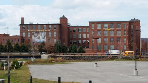
American Textile History Museum building
Textile Museum Building Plans
Last Monday, the Sun had an article about the future plans for the American Textile History Museum building on Dutton Street. The Museum closed permanently last year and the new owner, John DeAngelis, hopes to revive the building as a combination of residences and commercial uses, much like the very successful Mill No. 5 is already doing. Plans call for adding 15 residential units (which will give the building a total of 60) along with 20 to 30 small shops and a restaurant with outdoor patio space.
This is great news, especially since the developer has an established track record of projects in this city. But nothing he mentioned addresses the problem of Dutton Street. From City Hall to the Lowell Connector, the Dutton/Thorndike Street corridor is designed to be a high speed auto route between downtown and the Connector (hence it’s formal name, the Sampson Connector). The 1960s-era planning that brought us the Sampson Connector was antithetical to walkability. Just as the attractiveness of housing in the Acre and Lower Highlands is diminished by the difficulty of crossing Dutton/Thorndike on foot, so will the future success of the DeAngelis project turn on the ability of people to easily walk from downtown to the site – something that’s not possible now.
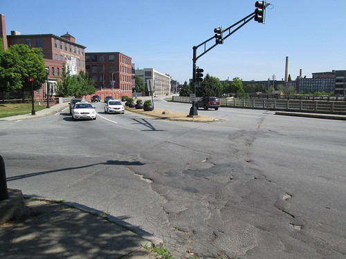
Dutton/Thorndike Street – no place for walkers
The upcoming Lord Overpass renovation/replacement project is our best hope of remedying this walkability problem. But I can’t remember the last time we heard anything about the Lord Overpass planning process from City Hall. Maybe it’s time for another public meeting.
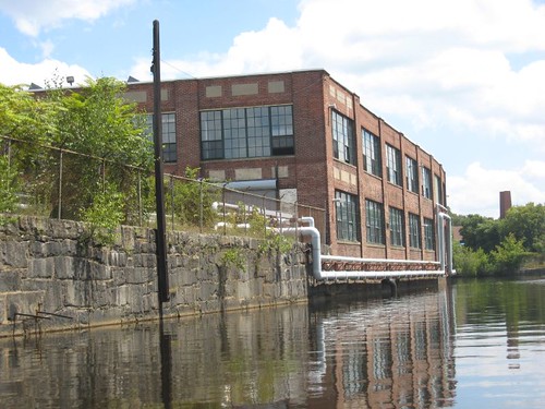
Pawtucket Canal and rear of Western Avenue Lofts
Upper Pawtucket Canalway
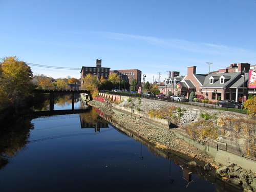
Related to the above is a project still in the conceptual stage called the Upper Pawtucket Canalway. To remind everyone, the Pawtucket Canal runs from the Merrimack River and Pawtucket Street (near UMass Lowell South Campus and alongside the Lowell Motor Boat Club) all the way to the Concord River behind the UMass Lowell Inn & Conference Center. The “upper” portion of the Pawtucket runs from the river to Thorndike Street, running mostly between Middlesex and Broadway streets.
Lowell National Historical Park already has a portion of this walkway in place. It runs from the river to the Francis Gatehouse on Broadway. The National Park hopes to extend this walkway all the way to Thorndike Street and the Hamilton Canal District. It is my understanding that the National Park already controls canal-side right-of-way access sufficiently wide to accommodate a walking and biking pathway with a planted bed separating it from the adjacent private property, so there will be no need for costly and time-consuming property-right acquisitions.
All that is needed now is the funding. But if you’ve been paying attention to the national news, the likelihood of several million dollars coming from Washington to someplace in Massachusetts for construction of a canal side walking and biking trail is beyond remote. However, that should not cause the project to be abandoned or moth balled.
As a community, we should come together to pursue the accomplishment of this Upper Pawtucket Canalway. Think of the benefits to UMass Lowell. This would provide a direct bike and walking route from the Gallagher Terminal to the school’s South Campus. It would also provide a ready pathway for residents of the Acre and Lower Highlands directly into the Hamilton Canal District.
Pawtucket Canal from Thorndike St. Western Ave Studios in background. Canalway would be on left side of canal.
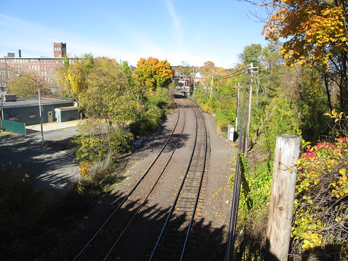
Railroad tracks from Lord Overpass. Western Ave Studios in upper left. Canalway would pass under these tracks alongside the Pawtucket Canal
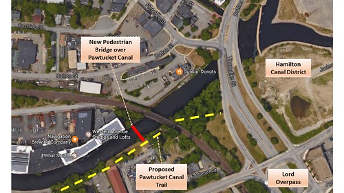
And the Upper Pawtucket Canalway might help solve a problem that has plagued the city for several years – how to create pedestrian access from Western Avenue Studios to downtown. The proposed Canalway is across the Pawtucket Canal from Western Ave, but a pedestrian bridge across the canal from Western Ave to the Canalway would be feasible and affordable. Then the Canalway would dip underneath the railroad tracks that have been the insurmountable obstacle to pedestrian access. Because the tracks are several feet above the elevation of the canal bank, a pathway going underneath the tracks would only have to dig down a few feet with gentle slopes leading to and from it.
Because this section of the Canalway is immediately adjacent to the Lord Overpass, perhaps some of the money being spent to remake the Overpass could be utilized to do this short stretch of the Canalway plus the pedestrian bridge to Western Ave. Doing that would solve the Western Ave access challenge and would also jumpstart construction of the longer Canalway.
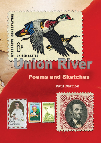
Union River Benefit
This coming Wednesday, May 3, 2017, at 4 p.m. at Mill No. 5’s Luna Theatre at 250 Jackson Street, Paul Marion will have the official launch of his new book, Union River (which I reviewed last week). Instead of a normal book launch event, Paul has teamed with the Lowell Plan to make the event a benefit of Public Matters, the Lowell Plan’s civic engagement program, which has helped train hundreds of young people for greater participation in the public life of Lowell. The suggested donation is $50 and can be paid at the door. The price includes an autographed copy of the book.
Lowell Walk next Saturday
Next Saturday, May 6, 2017, at 10 a.m. at Lowell National Park Visitor Center at 246 Market Street, UMass Lowell Professor Bob Forrant and graduate student Rachel Arnason will lead a Lowell Walks tour on the Labor Movement in Lowell. The event is free, requires no advance registration, and will last about 90 minutes.
For more information about these and other upcoming events, please check out our Events page.
Lowell City Council Meeting: April 25, 2017
I missed the live broadcast of last Tuesday’s council meeting and caught a replay yesterday. Here is a summary of the major items discussed by councilors:
Finance Subcommittee report from April 24 subcommittee meeting, given by subcommittee Chair Rodney Elliott. Recommended motion that city manager prepare a report on the benefits and detriments of a debt inclusion ballot question for the Lowell High project. The second proposed motion is that the city CFO make an estimate of increased tax impact per property based on the expected price of the High School project.
A report already received by the subcommittee showed that 95% of the homes in the city will share the largest expense. Those are the houses valued between $250,000 and $450,000. These homes would experience an annual tax increase of $266 to $515. The subcommittee also reviewed how much taxes have increased over the past five years. During that time, it was a $100 cumulative increase spread over the five years which Elliott contrasted with the much larger single year (and continuing) increase associated with a new high school.
The subcommittee will continue to meet and explore the costs. Councilor Elliott says he has supported the high school project from the beginning, but over time it has grown from $250mil to $345mil which he says is a “staggering number.” He said the project is like a “runaway train” and he doesn’t know “how we can sustain this cost” or how homeowners will be able to afford the tax increase to pay for it. Elliott suggests that the project should be scaled back considerably to reduce costs and to construct something we can afford.
Councilor Leary speaks on the request for information on debt exclusion. Says he wants information but also a recommendation from the city manager. Says if we built a new high school ten years ago, it would have been $150mil. If we wait another ten years, what will it cost then? Says the only shortcoming for the high school in its last accreditation report was criticism of the physical plant, so that must be addressed, otherwise the city risks losing accreditation of the high school.
Downtown Redevelopment subcommittee report given by Councilor Milinazzo. Subcommittee received a report on Lowell House/CBA proposal to build sober housing on upper Merrimack Street. Lowell House reports that it has reached an agreement/partnership with Lowell Community Health Center to base the clinical services with LCHC on Jackson Street. The CBA will then buy the existing Merrimack Street property now occupied by Lowell House, demolish that building, and construct in its place approximately 28 units of sober housing with commercial units on the first floor. The subcommittee voted to support the partnership and the project and offers the same as a motion for the full council’s consideration. The treatment facility will cover all addictions from alcohol to opioids. The council votes 8-0 to support the proposal.
Motion by Councilor Milinazzo asks for a report on personal property tax on artists, especially those at Western Ave (this was featured in a recent Boston Globe story). Motion passes; report will be forthcoming.
Lowell City Council Meeting: May 2, 2017
Here are some items included the information packet regarding this coming Tuesday’s council meeting:
Tanner Street Realignment – There’s a memo in this week’s city council packet regarding the Tanner Street alignment which is part of the bigger Ayers City Redevelopment project. The memo, from Kevin Coughlin to Kevin Murphy, reports that a breakthrough has occurred. The VFW will now sell to the city a portion of its property between Plain and Montreal streets which will allow the realignment of Tanner Street to move forward. This will cause Tanner Street to meet Plain Street directly opposite the entrance to the Target plaza where there is an existing traffic light. As part of this project, the VFW will construct a new but smaller building on another portion of the existing parcel. This new building will better fit the needs of the VFW. The city has Watermark Engineering continuing with the design work of this intersection. The VFW is expected to break ground on its new business in November 2017, so work on the street realignment will begin sometime after that.
Broadway Bridge – The reconstruction of the Broadway Bridge over the Pawtucket Canal began back in January 2016 with an expected completion date of December 2016. Due to delays in the work, the new completion date is October 2017.
The following motions will be taken up by councilors:
- Leahy – Req. City Mgr. explore feasibility of creating an ordinance to ensure permits are issued between 60 and 90 days from incident in order to rehab or demolish a fire damaged structure.
- Samaras – Req. City Mgr. request Supt. of Lowell Schools prepare a presentation and/or report regarding buildings needed to meet the educational plan for the Lowell School system.
- Belanger – Req. City Mgr. update City Council regarding JFK Plaza improvements.
- Leary/C. Leahy – Req. City Mgr. initiate an inquiry for a financial review; specific to all Gateway Cities School building projects, as it relates to a needed increase to the square foot reimbursement rate with the MSBA and Treasurer Goldberg.
- Leary – Req. City Mgr. work with the DPW in order to improve the road conditions on Ruth Street.
- Leary – Req. City Mgr. work with the appropriate department in order to improve the road drainage issues between Alcott Street and Windward Road.
- Elliott – Req. City Mgr. have Inspectional Services initiate neighborhood “SWAT” team to address code violations at dilapidated properties in City.
- Elliott – Req. City Mgr. report on current repairs needed at Lowell High School.
- Rourke – Req. City Mgr. have Building Dept. enforce an ordinance mandating that all non-owner occupied buildings and construction sites in the City display a sign indicating a 24 hour working phone number, email address as well as a current street address for inquiries; sign to be at least 18 inches by 12 inches with 1 inch font and displayed at all entrances and exits; any non compliance after October 1, 2017 will be subject to fine of $100 per day.
The delay with the Broadway bridge should provide a heads-up to the plans for updating/replacing 6 other bridges with the help of UML and the TIGER grant. The design for those other bridges was to be completed by the end of April in anticipation of going out to bid this summer in order to comply with the grant requirements. Then cost, schedule and traffic issues will become issues if not planned properly.
Commenter Brian on that last thread was absolutely right about a “noose around the downtown.” There are highway-like streets and strip malls with big parking lots almost all the way around. We need to restore the old connections between the downtown and the historic neighborhoods that surround them.
But we don’t need to import a ton of people to live in those neighborhoods; they’re already full of people! And If you look at Cupples Square or Bridge Street or Clemente Square, the neighborhood commercial districts are bursting at the seams. There is more demand for storefront space produced by the existing residents of those n’hoods than their commercial centers can provide. If we better connect them to downtown, storefronts there can fill up with businesses for those inner-neighborhood residents.
We need more residents in the downtown itself; let’s see some more towers! The 400 kids in the private dorm, the Bostonians who will pay way too much to live at 1 East Merrimack Street – we should go for as many new units in downtown as we can. We absolutely do not need to gentrify anyone in the neighborhoods out of their home in order for downtown to succeed.
Joe from Lowell,
Great point about the neighborhood commercial districts. One area that is ripe for some attention is Andover St at High St. There are many thriving small businesses there but too many parking lots on the stretch from High St to the Concord River.
I’m convinced the impediment to good development in the city is zoning and planning. I’m not saying the boards are doing a bad job but doing what is within the rules and getting bad outcomes. So change the rules!
The council could incentivise development by eliminating parking requirements there if developers agree to build ground floor shops with upper floor housing or office space above. The city could then install parking meters to help the businesses. Rents would be cheaper without having to provide parking.
I’ll add we don’t need 11 story towers like 1 East Merrimack St to fill up downtown. 3-5 story mixed use buildings are at a scale that humans are comfortable walking around, like Middle St, and similarly have to be built right up to the curb to enhance the public realm. If the code calls for setbacks and greenery on Andover St change the code.
Providing work and housing opportunities for people in the “struggling” neighborhoods makes economic sense and is the right thing to do.
That section of Andover Street at the Concord River is a unique location in the downtown where big buildings with setbacks actually work. The LMA, the federal building, the UMass Inn and Conference Center, the IC Church, and the MCC building on the island are all big, have open space around them, and most of them are connected by a system of walkways along the water. The tower fits that. The reason this district works in our pedestrian-urban downtown is the district’s compactness – just a couple of blocks, which then transitions right back, abruptly, into the smaller, tighter urbanism that we associate with downtown. The big tower project matches that, too, extending the Concord River Greenway right up to East Merrimack Street and featuring a restaurant facing the canal, across from other restaurants that do the same on the other bank. That same design would be detrimental, and detract from the walkable, cozy feel, anywhere else in downtown, but it works there.
Joe Boyle,
I think you’re confusing Andover St,of which I’m advocating attention, with East Merrimack st.
The LMA and IC Church had setbacks because they were high intensity community gathering spaces that were surrounded by tight urbanism. Look at the old photos of east Merrimack and every building was built up to the sidewalk.
MCC’s setback accommodates parking and hurts the public realm. Speck pointed this out and recommended a park.
The Gormley block and Buick building fit nicely in the neighborhood.The remaining parking lots if built upon should not have setbacks. 1 East Merrimack could have been built along east Merrimack and the canal greenway by moving the parking lot in the back along Davidson St.
IMO the district would work better with tighter urbanism.
East Merrimack Street, right. That tower.
Most of our large old sites that exist within the generally small-scale matrix of downtown are a legacy of a time when those locations were very intensively used. Now, that form itself is definitional to the place.
A park, like the auditorium’s lawn, in the federal building’s yard would be great, exactly the walkable riverside open space that define the district already.
I’d love to see those two little parking lots on either side of Davidson and East Merrimack get built up to the sidewalk. If the 1 East Merrimack Street project could have acquired that parcel and built up to the sidewalk, that would have been ideal; the facade along the street reflecting the dense urbanist design and the side along the river set back for the greenway.
It wouldn’t have required an expensive acquisition but a land swap. For such an important project for both Daly and the city it was a missed opportunity.
As always Jane Jacobs nails it “In the absence of a pedestrian scale, density can be big trouble.”