Manning Field
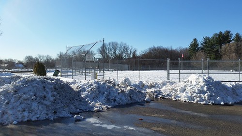
Manning Field looking south towards Chelmsford line. Boston Road is to the left.
Manning Field, a little-known complex of two Little League/softball fields on Boston Road on the southern perimeter of Lowell, has been in the news lately as a possible “replication” site for greenspace at Cawley Stadium that is encumbered by state use restrictions. The city wants the option of constructing a new high school on the Cawley site which requires the removal of the restrictions. The procedure for doing that, which is set out in Article 97 of the Massachusetts Constitution, requires, among other things, that the encumbered greenspace be replicated in size, quality, and usage, elsewhere in the city. Hence, the focus on Manning Field.
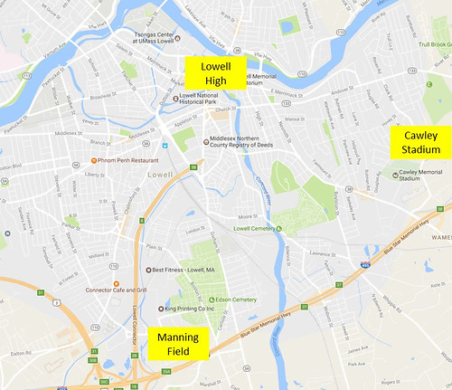
To give a sense of the location of Manning Field to those unfamiliar with it, on the above Google map, I’ve labeled the current site of Lowell High School in the city’s downtown; Cawley Stadium in the Belvidere neighborhood; and Manning Field which, neighborhood-wise, is in (a) the Highlands, (b) Ayer City, (c) South Lowell, or (d) none of the above. I pose that as a multiple choice question because I’m not sure of the answer myself.
If you asked me for driving directions, I’d tell you to take Plain Street outbound from Chelmsford Street, go under the Lowell Connector, past Target (on your right) and Lowell Car Wash (on your left). Just beyond that point, Plain Street becomes Boston Road and you pass between the rear of St. Patrick’s and Edson Cemeteries, and the front of the Holy Trinity and Westlawn Cemeteries. Just past Swan Street (which connects to Industrial Ave) is Manning Field.
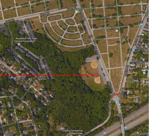
The overhead photo above zooms in on Manning Field. Note the two baseball/softball fields in the middle of the picture. Boston Road is to the right. Across Boston Road is Edson Cemetery. The highway at the bottom of the photo is Route 495 (which would be convenient if you were coming from Belvidere only there’s no exit nearby). The built up area to the left of the fields is the Woodland Park Condominium Complex. The geometric design above the fields is the Westlawn II Cemetery (see photo below). The red line that cuts horizontally across the photo is the city’s boundary. Above the line is Lowell; below it is Chelmsford. Yes, part of Manning Field is in Chelmsford, although the land is owned by the city of Lowell.
The land that comprises Manning Field and Westlawn II Cemetery came to the city of Lowell in the 1920s as two different parcels. On September 14, 1922, the Lowell City Council voted to take by eminent domain, 17.21 acres of land at the southwest corner of Swan Street and Boston Road from the estate of Erastus A. Bartlett, late of Chelmsford. The taking was made to acquire the land “for public cemetery purposes.”
Looking at the overhead photo again, this 17 acre parcel was bounded to the north by Swan Street for a distance of about 700 feet and to the east by Boston Road for a distance of about 1000 feet. The southern boundary of this parcel is the Chelmsford line. The western boundary today would be the Woodland Condominium complex.
The second parcel lies to the south of the land taken by eminent domain. This parcel was also owned by the Estate of Erastus A. Bartlett. It lies entirely in the town of Chelmsford. The city of Lowell purchased it from the Bartlett Estate for $7455. This parcel consists of 15.07 acres. In the overhead photo, it is the wooded area and the ballfield that lie to the south of the Lowell-Chelmsford boundary (the red horizontal line).
Together, these two parcels total 32.28 acres with approximately one-third of the area taken up by the Westlawn II Cemetery.
Other than the original purpose of the eminent domain taking of the Lowell parcel – use as a public cemetery – I could find no restrictions on the use of the property recorded at the registry of deeds. Of course, just because there is not something recorded, doesn’t mean that there are not enforceable restrictions on the land. Oh, and there seems to be a lease for a cell phone antenna somewhere on the property, but that shouldn’t impede its use for recreational purposes.
So that’s Manning Field. Whether there’s a new high school built on Cawley Stadium or not, I’m sure that the Woodland Park neighbors and others living in the vicinity would welcome some improvements to this publicly-owned greenspace.
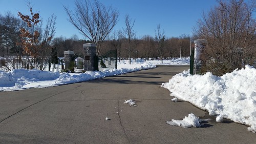
Westlawn II Cemetery, looking southwest. Taken from corner of Boston Rd and Swan St
Thank you for sharing this information. Some I knew and some I did not. I always find your articles quite interesting so please keep them coming.
Dick,
Article 97 does not require replication of lost park space. It’s administrative policy that may ask for replication. Think of it as the difference between a Law and an Executive Order.
Steve
In the early 1960’s, Manning Field was built for an “expansion” little league that had started on the current site of Lowe’s on Chelmsford St. I played in that league, and most players were from the Highlands, so I’d consider it part of the Highlands.
Cemetery related not high school related, what is the future of lowell cemetery needs? Doesn’t the Cemetery Commission plan for future burial needs.
So you would like to rip down my little brothers park.Matthew Ventura Memorial Park
Most people, unless they had kids in youth baseball, would have no idea where or what it was. Probably the only fields in Lowell that we unreachable by walking. For a lot of us, it was a 2-3 mile bike ride to nowhere. Any improvements to that area, would be a blessing.
I played there in the late 60’s and lived off off Stevens St. Less than 6 streets from Callery Park.
No ride, no game.
Dick, I would say it’s Ayer City. If I recall there use to be a sign on Connector indicating Ayer City in that direction out Plain St
Going back a few years to the cell phone tower hearings…… according to the attorney for Sprint (at the time) he said that they had bought the land and not leased it.
Great information! I had thought the Chelmsford/Lowell line was at the bridge, when in actuality it’s not. I guess that’s why it’s always Chelmsford Police cruisers that are waiting to catch speeders near the park.